

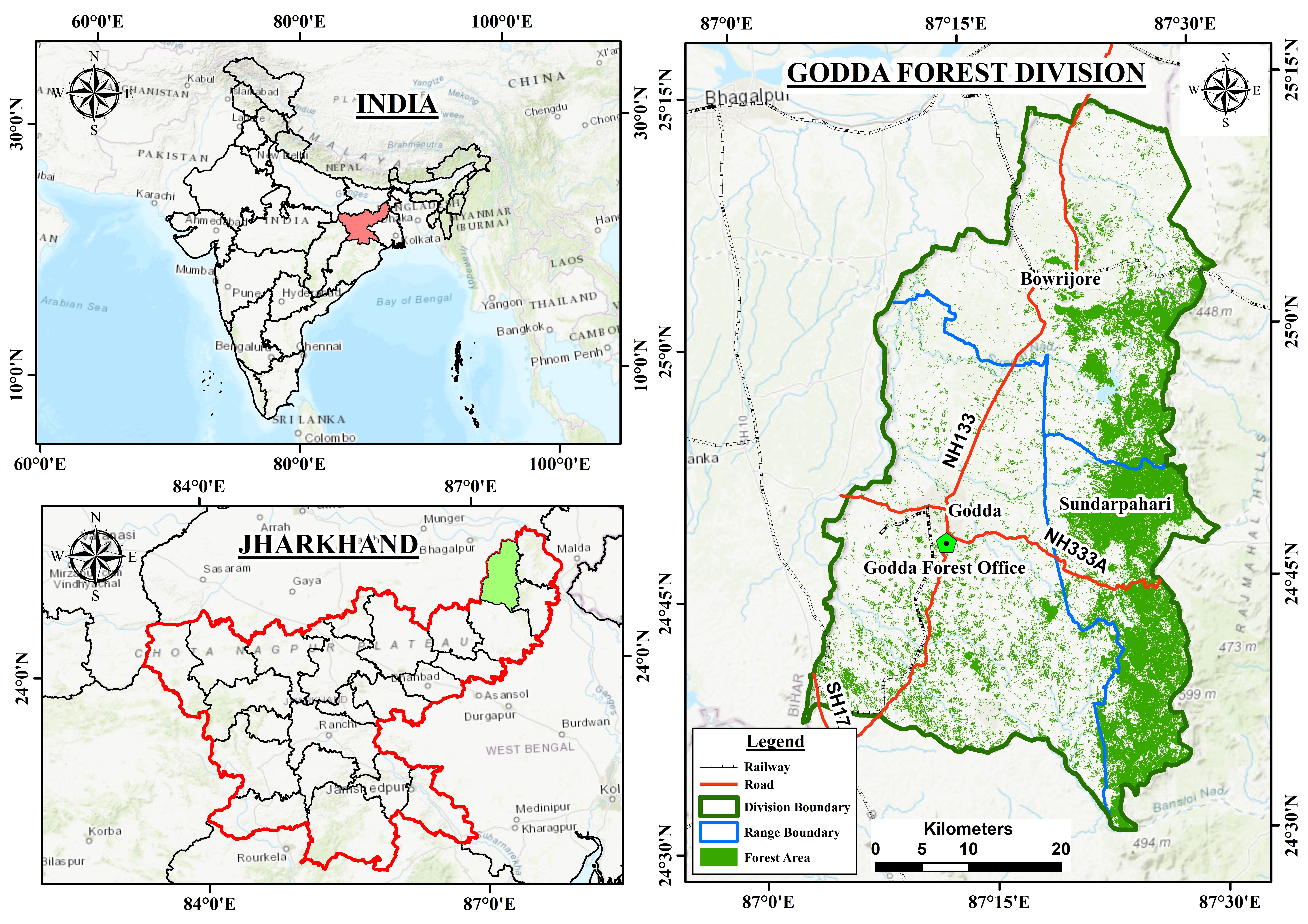
The Godda Forest Division is one of the important forest administrative divisions under the Department of Forest, Environment and Climate Change, Government of Jharkhand. It is situated in the north-eastern part of Jharkhand between 24°30'08" N to 25°13'42" N latitude and 87°02'44" E to 87°31'19" E longitude. The division is bounded by Bhagalpur district of Bihar in the north, Dumka district in the south, Sahibganj and Pakur districts in the east, and Banka district of Bihar in the west. The total geographical area under the division is approximately 2,266 km². The division is known for its tropical deciduous forests, rich biodiversity, tribal culture, and significant ecological importance. It comprises three forest ranges: Godda Range, Boarijore Range, and Sundarpahari Range. The forests provide habitat to numerous plant and animal species while supporting the livelihoods of local communities through forest products such as Sal, Sagwan, Timber, Bamboo, Mahua, Neem and Medicinal plants.
Historically, the region formed part of the ancient Santhal Pargana area. During the Turko-Afghan period, the region was administered by Sher Shah Suri and his successors. Later, under the Mughal Empire, it came under the administration of Raja Man Singh. During British rule, the forests of the region were extensively exploited for economic and strategic purposes. The area is closely associated with the Santhal Rebellion (Santhal Hul) of 1855–56, led by Sidho and Kanho Murmu against British oppression and exploitative zamindari practices. The rebellion resulted in the creation of the Santhal Pargana administrative unit. Godda remained a subdivision of Santhal Pargana until it was declared a separate district on 25 May 1983. Following the formation of Jharkhand on 15 November 2000, Godda became one of the state's important administrative districts.
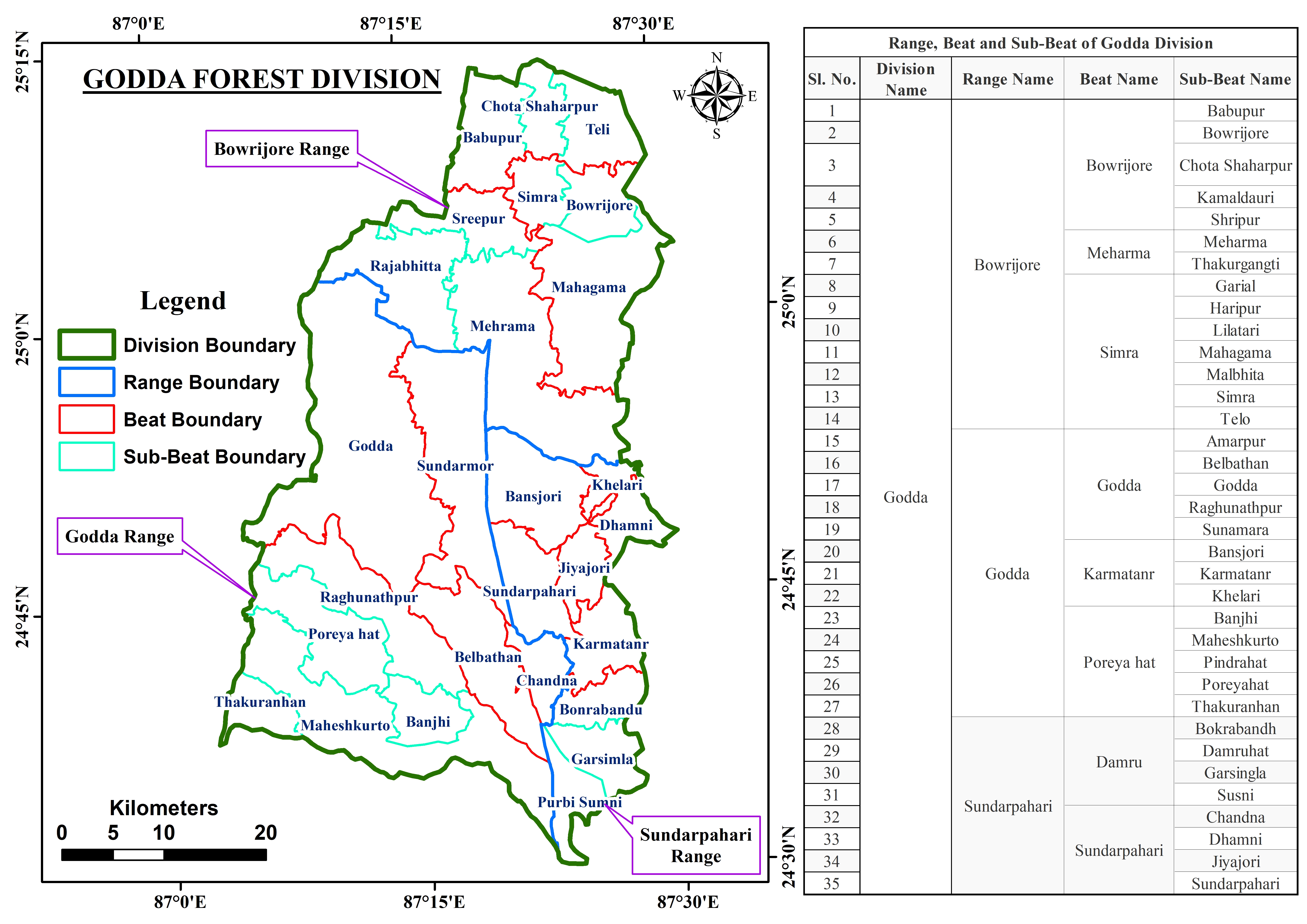
The Godda Forest Division is administratively divided into three forest ranges, comprising several beats and sub-beats for efficient forest management. The division is headed by the Divisional Forest Officer (DFO) and supported by Range Officers, GIS Expert, Foresters and field staff responsible for protection, afforestation, wildlife conservation, and community forestry activities.
The physical landscape of the Godda Forest Division is characterized by a combination of undulating uplands, hills, hillocks, valleys, and plains. The western and southern parts are associated with the Rajmahal Hills, especially in the Boarijore and Sundarpahari regions. Elevations generally range between 80 and 500 metres above mean sea level. The forests are predominantly tropical dry deciduous forests. The soils are generally reddish-yellow to brown in colour, acidic in nature, light to medium textured, and moderately to highly permeable, with relatively low water-holding capacity. Coarse-loamy and loamy-skeletal soils occur in localized upland and hill-slope regions, while fine textured Vertic soils are found in low-lying areas. The dominance of Ustochrepts and associated Alfisols reflects the undulating terrain, weathered parent materials, and tropical monsoonal climate of the region.
The soils of the Godda Forest Division are highly heterogeneous and belong predominantly to the Entisols, Inceptisols, Alfisols, and Aquents soil orders. The area is mainly characterized by fine loamy Typic Ustochrepts, which occur extensively across the division, often associated with Typic Paleustalfs, Typic Haplustalfs, and Typic Ustorthents. In the northern and northeastern parts, soils such as Aeric Haplaquepts, Psammaquents, and Vertic Ochraqualfs are present, indicating areas influenced by seasonal moisture and drainage variations.
The soils are generally reddish-yellow to brown in colour, acidic in nature, light to medium textured, and moderately to highly permeable, with relatively low water-holding capacity. Coarse-loamy and loamy-skeletal soils occur in localized upland and hill-slope regions, while fine textured Vertic soils are found in low-lying areas. The dominance of Ustochrepts and associated Alfisols reflects the undulating terrain, weathered parent materials, and tropical monsoonal climate of the region.

The predominant physical feature over most of the division is rolling and undulating topography dotted with isolated inselbergs, except in the Borijore and Sundarpahari blocks where extensive forest cover is present. The elevation generally increases from west to east. The landscape consists of uplands, isolated hills, valleys, long ridges, and depressions. The western extension of the Rajmahal Hills passes through the division, while prominent highlands such as the Masanjore hills occur in the adjoining Dumka district. Geologically, the area is composed mainly of basaltic trap formations and sedimentary beds, with occurrences of quartz and gneiss in some locations.
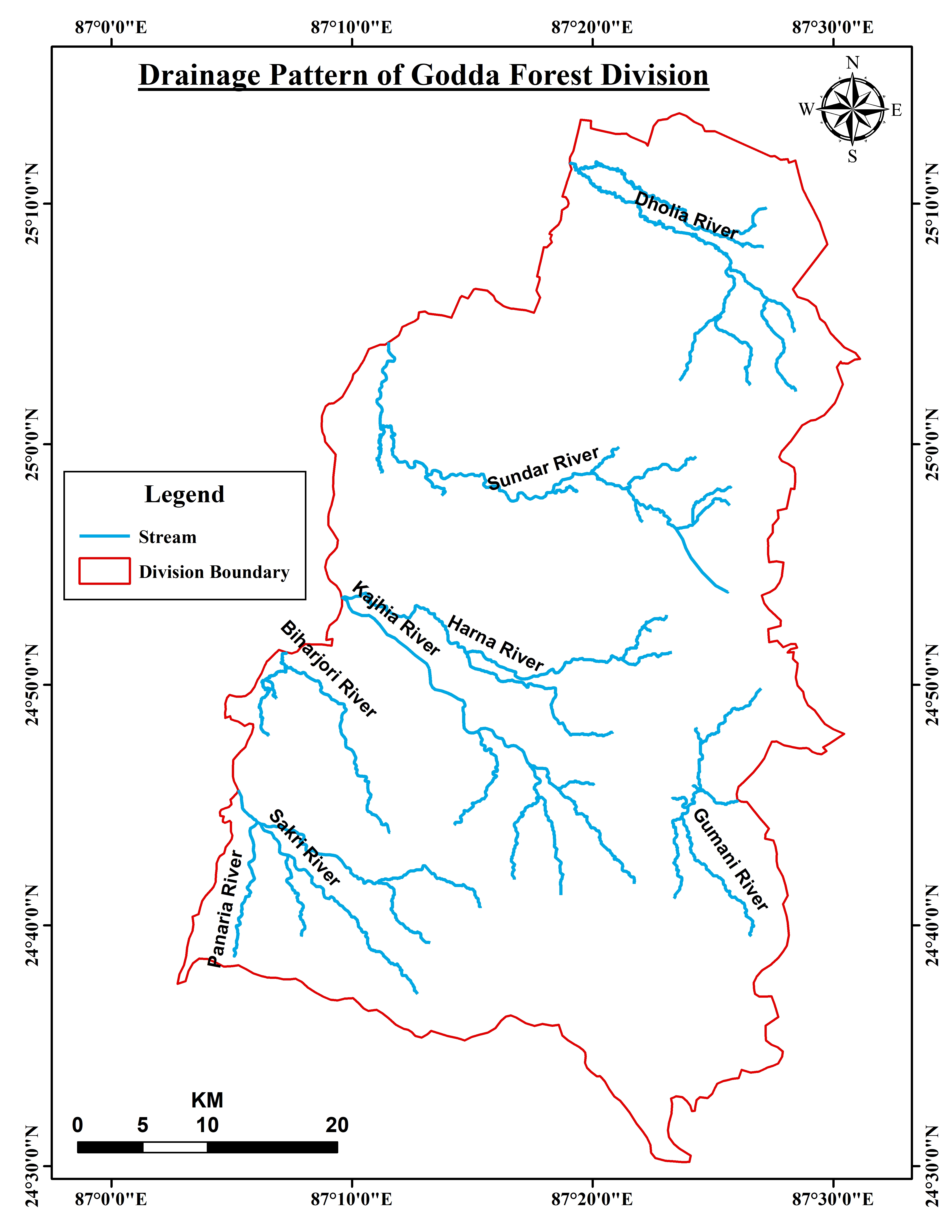
Major rivers flowing through the division include the Kajhia, Harna, Sundar, Dholia, Biharjori, Gumani, Sakri, Panaria and Geura rivers. The division falls within the tropical monsoon climatic region, characterized by hot summers, a distinct rainy season, and mild winters. The climate remains relatively pleasant due to the influence of surrounding forests and hilly terrain.
Godda Division is rich in mineral resources, particularly coal deposits associated with the Rajmahal Coal Mining Limited. The famous Lalmatia Open Cast Coal Mine, operated by Eastern Coalfields Limited (ECL), is among the largest open-cast coal mining projects in Asia. Coal mining contributes significantly to the regional economy and provides employment opportunities to thousands of people. Mining activities have contributed to industrial development but also pose challenges related to environmental degradation and forest conservation. The Forest Division plays an important role in mitigating these impacts through afforestation and ecological restoration programs.
The Godda Forest Division encompasses areas inhabited by diverse communities, including tribal and non-tribal populations. The predominant tribal groups include:
Boarijore and Sundarpahari blocks are particularly known for their significant tribal population.
According to Census 2011 data:
| Parameter | Value |
| Total Population | 13,11,382 |
| Male Population | 6,78,486 |
| Female Population | 6,32,878 |
| Rural Population | 12,62,913 |
| Urban Population | 48,469 |
| Literacy Rate | 43.73% |
| Villages | 2,311 |
| Blocks | 9 |
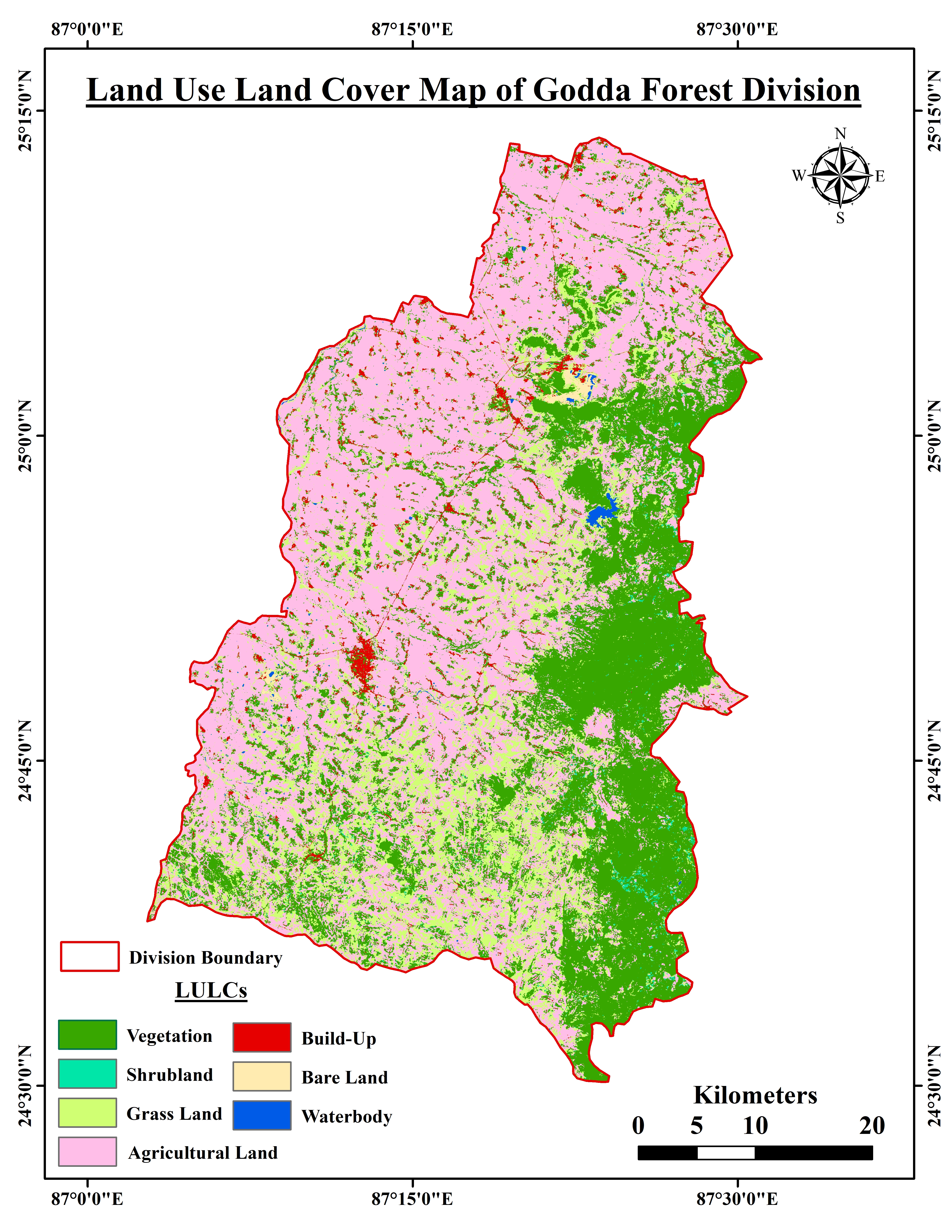
The LULC map of Godda Forest Division shows the spatial distribution of major land cover classes including vegetation, agricultural land, shrubland, grassland, built-up areas, barren land, and water bodies. Agricultural land is the dominant class, covering large portions of the division, while dense vegetation is mainly concentrated in the eastern and southern forested regions. Forest and vegetation areas indicate significant ecological resources, supporting biodiversity conservation and sustainable forest management. Built-up areas and water bodies occupy comparatively smaller portions, highlighting the predominantly rural and natural landscape of the division.